
Wrecks, Tides & Streams
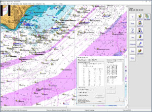
Ideal for anyone with an interest in our maritime history, this program plots and displays the details of thousands of wrecks and obstructions around our coastline, with depths, date sunk, cargo and the circumstances of loss.
With its inbuilt tidal height and tidal stream calculations it predicts tidal height and tidal stream details around the UK coastline for many years into the future.
For the diver and the fisherman it produces reports of slack and flood water times, which along with its other functions makes it very useful for planning dive times and producing a SOLAS type passage plan.
Version 11 is touch screen friendly and contains data up to the adjacent continental coastline.
Windows may warn you, or look as though it has blocked the file, before it will let the installer run. That is because our installers are not code signed, not because there is anything wrong with them. Choose Keep, then More info and Run anyway. Step by step, with screenshots.

Prices
| Item | Price |
|---|---|
| Wrecks, Tides and Streams program | £30.00 |
| Chart portfolio, each. At least one is needed | £29.00 |
System requirements
Windows 8, 10 or 11. Processor speed 1.6 GHz, 2 Gb RAM, typical hard disk space 300 Mb.
Features
Wrecks and obstructions
- Slack water reports
- Wrecks database
- User dive site database
- Obstructions database
- Filter by name and date
- Vessel type and cargo
- Image viewer
Tidal streams
- Raster charts
- Dynamic tidal stream
- Wind grid
- Tidal stream roll function
- Waypoint editor
- Tidal vectors
- Interfaces to GPS
- Night palette
- Range circles
- Configurable displays
UK tides
- Instantaneous tidal predictions
- Calculates tables and curves
- No annual updates required
- Daily and monthly tide tables
- Tidal rate of the rise and fall
- Neap to springs meter
- Primary and secondary ports
- Predictions include your own depth
- Draft and under keel clearance
- Next and previous port option
- Sunrise and sunset indicator
- Predictions to the year 2060
- Lunar phases
- Tide roll function
- Data derived from UKHO sources